
Aruba Outdoor RF Planner
Simplify Outdoor Mesh Network Design with the Aruba Outdoor RF Planner
Overview:
Designing an RF network can be a complicated task, even for experienced systems integrators and network architects. The Aruba Outdoor RF Planner makes it quick and easy to accurately design 802.11n mesh networks to meet customers' business and technical requirements.
The Outdoor RF Planner is a free, web-based application that is purpose-built for outdoor applications. Systems integrators can use the graphical topology planning tool to fully visualize the wireless mesh network, including RF coverage heat maps, client access and mesh links. It provides expert mesh network design guidance and eliminates the need for time-consuming manual calculations.
The Aruba difference
- Visualize outdoor 802.11n mesh network coverage
- Generate outdoor RF coverage estimates
- Rapid, accurate outdoor mesh network design
- Web-based application works with Google Earth
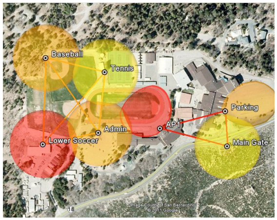
Designers can easily visualize both the Wi-Fi client coverage and the mesh backhaul links.
Features:
Visualize RF coverage outdoors
The Outdoor RF Planner makes it vastly simpler for systems integrators to visualize RF coverage for the mesh backhaul and plan for Wi-Fi client coverage and data rates. Gone are the days of puzzling through antenna pattern plots, two-dimensional drawings and complex calculations.
The Outdoor RF Planner uses a proprietary process to superimpose full three-dimensional antenna patterns onto Google Earth representations of outdoor terrain. Integrators can choose different antenna patterns and transmit-power levels to visualize the expected 3D coverage for each network design. With the Outdoor RF Planner, the resulting maps are based on actual antenna patterns for greater accuracy.
Designers can see the RF design in 3D, both from a plan view and an elevation view. Elevation views in the Outdoor RF Planner provide visualizations of vertical coverage from high mounting locations, such as rooftops and towers.
Rapid design for outdoor networks
The Outdoor RF Planner accelerates the design process for outdoor mesh networks. In many cases, systems integrators can cut planning time from weeks to days or even hours. The planning tool is designed to be used by both RF engineers and network engineers, and can provide a wealth of planning information before making any onsite visits or surveys.
As a web-based application, the Outdoor RF Planner puts complexity in the cloud - not on the engineer's computer. The Outdoor RF Planner makes mesh network calculations using an innovative on-the-fly scaling method. Designers can easily change the RF parameters, and the design is uniformly and quickly scaled.
Simplified troubleshooting
The Outdoor RF Planner helps integrators avoid common mistakes in outdoor mesh network design. For instance, a designer may specify a high-gain antenna to provide coverage, but when the network is deployed, the RF coverage is not reaching where it's needed.
Integrators can avoid these problems by getting a full 3D view of the vertical coverage during the design phase, and seeing the effects of adjusting the antenna direction and mechanical downtilt to deliver optimal coverage.
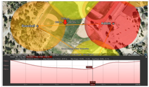
Designers can see a full elevation profile for the mesh links so they can avoid mistakes commonly made when determining the vertical coverage.
Reporting and inventory
The Outdoor RF Planner produces detailed reports that can be used for planning and ordering Aruba mesh routers and antennas. The reports show the mesh network model, including country, design margin, location details, access points (APs) and antennas selected, antenna heading, and mesh roles. The report also details the mesh links, which are color-coded for associations according to date rate.
In addition, the Outdoor RF Planner provides a bill of materials for the APs and antennas, which simplifies ordering the equipment.
Using the Outdoor RF Planner
Creating an outdoor RF coverage plan for a site begins with developing a model of the mesh network. The Outdoor RF Planner simplifies this process by walking through country specifications, client types, AP locations, altitude parameters and whether the environment is noisy or quiet.
Parameters can also be set to provide a general design safety margin. For instance, a higher design margin might be ideal in an area with trees and other potential elevated RF obstacles.
Image overlays, such as CAD drawings and facility maps, can be added to the network model to assist in the accurate positioning of the Aruba APs. These APs may be placed manually on the map, or GPS locations can be imported into the project file to automate this task.
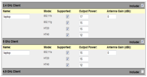
Client models describe the typical clients in an AP grouping. Client power can be defined by band and mode, and antenna gain can be defined by band.
From there, the Outdoor RF Planner can select the Aruba APs, antennas and mesh roles. A default model for the APs and antennas can be chosen or customized values can be used as needed. The number of available radios will depend on the Aruba AP selected, and the band and mode assignments are based on the AP model. Channels can also be assigned for planning purposes.
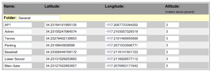
Locations represent any specific point on the map. A location may be an access point or antenna or a convenient label like tennis court or baseball stadium.
Mesh associations can also be defined. The Outdoor RF Planner makes it easy to simultaneously inspect 3D client coverage with the 2D representation of the associated backhaul network. The design margin can be adjusted to show the RF coverage with reduced power.
Client coverage models can be generated based on TCP throughput or by signal level, which is typically used for voice over IP (VoIP) analysis. In addition, channels can be modeled based on a signal level for overlap or interference analysis.
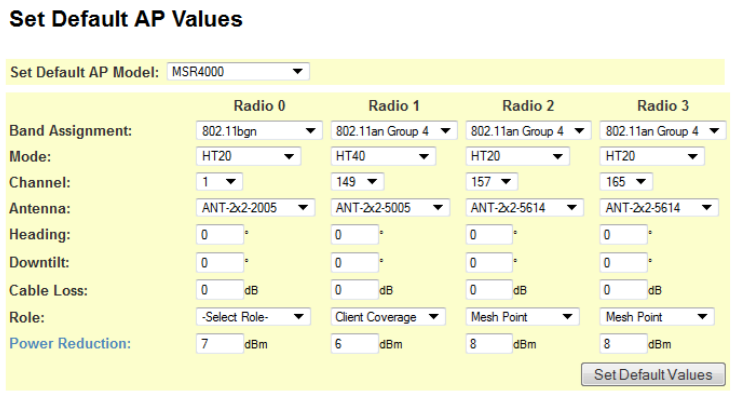
The Outdoor RF Planner default AP values can be used or values can be customized as needed. Channels can also be assigned for planning purposes.
The Outdoor RF Planner automatically conducts a series of checks, including verifying each mesh association for valid signal strengths at both ends of the connection, beamwidth alignment, Fresnel zone and earth bulge for long-distance links, and that the associated data rate for the mesh link is above the minimum rate specified.
Once the design specifications are complete, the webbased Outdoor RF Planner software will process the file, which can be downloaded as a keyhole markup language (KMZ) file. The final results can be viewed in Google Earth. Designers can run through the planner again to refine the heat maps and coverage as needed.

The Outdoor RF Planner displays 3D models of the coverage areas by the user-selected 802.11n throughput.

